 |
|

|
When Dayhikes Go Bad:
First time in the Palisades
by Scotty Strachan, with Barry Beck
Climbed August 17th, 2002 |
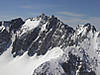
Thunderbolt Peak, 14,003
Starlight Peak, 14,200
North Palisade, 14,242
Polemonium Peak, 14,200
Mt. Sill, 14,162
Total Elevation Gain ~9,000'+
Total Mileage ~22mi+
Car-to-car time ~32hrs
|
| How far will ambition take you? In the High Sierra, that trip is measured in feet --- not meters, ladder rungs, or frequent-flyer miles. At some singular moment in their climbing career, the North American peak bagger will find themselves at 4,000 such feet in the Owens valley, staring up past 10,000 more at some of the most accessible and yet rugged mountains in the country. Wondering if they will make it. |
On maps, they are called the Palisades; five separate peaks along the highest continuous stretch of technical rock in the Range of Light. Their summits are easily glimpsed from byway picnic spots, but few passing tourists trouble themselves to cross the glaciers and scale the exposed arêtes or steep couloirs.
For me, that singular moment took place in the spring of 2002. Oh sure, I had seen them before in passing, but this time was different. Commitments were made to visit this toothed rent in the sky, and backing down was not an option. Others had survived. I had read their accounts in books or on websites speaking of beauty, challenge, and exposure.
That moment of visual realization felt oddly chilling, but not deathly so. It was early in the year yet, and there were many other things to do --- specifically, 10 other things. Barry Beck and I had resolved to kick off my first serious year as a Sierra peak bagger by summiting all 15 of California's 14,000-foot mountains. In dayhikes, and sight unseen for the large part. That particular day we were after Split Mountain, my first 14'er and the Palisades' not-too-distant relative. The register was signed, but the suffering involved coerced me to pray dearly for a rapid improvement in my fitness level. |
|
|
Summer arrived, and with every weekend came new summits. Our fitness did improve, drastically, as did our abilities. Always, on every trip, we would talk about "Palisade Day", and the inevitable time when we would face the Sierra's Big Five. In many ways, I could not seriously envision myself traversing what seemed in photographs an impossibly difficult ridge. In my mind, that approaching day was only an abstraction. The Whitney group was finished, along with White Mountain Peak, Langley, and Williamson. Every outing and summit seemed easier than the last, as we became acclimated and were motivated by our progress.
Suddenly, it was mid-August, and all the work-ups were done. We had 8 peaks left --- the Palisade Five, Middle Palisade just to the south, Tyndall (a remnant of the memorable Mt. Williamson hike), and the easy-but-distant Shasta. Middle Palisade we were saving for later, just in case we breezed Thunderbolt, Starlight, North Pal, Polemonium, and Sill with daylight to spare. This notion indicates that hypoxia at valley-floor elevations is always a possibility.
Information we had on the entire traverse was sketchy, to say the least. By pooling tidbits from various sources on each peak we put together a rudimentary plan, but fully anticipated on winging it from the Underhill Couloirs all the way to the East Sill Couloir. However, seeing the posted traverse times by various speed climbers, we figured we could at least score all five before dark. We were not far from the truth. |
|
At last the day dawned --- Saturday, August 17, 2002. It found Barry & me breaking camp at 0430 after the previous evening's drive down from Reno. We left the Glacier Lodge trailhead at 0523, and proceeded up the North Fork trail. The tranquil summer darkness gradually faded into light, with alpenglow illuminating one of the most awe-inspiring views from any Sierra trail. The aretes of Temple Crag soaring into the early morning sky, rows of forested glacial benches, and distant sounds of water, all rimmed by wild summits along the crest, is a visual experience that will linger forever. |
|
Given our plan to descend the South Fork of Big Pine Creek, we were obligated to take the longer approach to Thunderbolt Peak instead of the more desirable South Lake route. It proved to be indeed a long approach, with much of the morning passing before the Palisade Glacier was reached.
Climate-induced glacier shrinkage had left the head of the ice field far below the direct entrance to the Right-Hand Underhill Couloir, forcing us to scramble across dangerous, rubble-strewn ramps to access it. In retrospect, a direct 5th -class climb up the east face of T-bolt would have been much more satisfying. A quick, spooky 4th -class trip up the chute (where several rap slings were collected) brought us around to the southwest face of the peak. |
| Opting not to rope up, we proceeded to advance up slabs and short faces to the blocky summit ridge, bypassing the normal 4th -class chimney via some exposed and somewhat insecure 5th -class moves. At the top, a setback was suffered. Although I was carrying a short, 30m piece of 8.5mm dynamic, there did not seem to be any way to adequately protect the leader up the actual summit block. As it was almost noon, we did not want to waste time trying to set up a dubious belay across the top to the west side. We put our rock shoes on, messed around on the first holds a bit, and even tried lassoing the top against the wind. None of this was successful, as we were much more interested in staying alive than hanging it out on a 5.9 move. In the end, we said hello to the register and bugged out. |
|
|
| Reversing our route to the Starlight col, we carefully made our way ropeless up to the infamous Milk Bottle. This was a pleasurable portion of the traverse, as scores of bizarre gendarme formations are encountered along the crest, with nothing but air between them and the glacier far below. Upon arrival, Barry began flipping through the Starlight register while I poked around the Bottle's base. |
|
Again, a belay with a small diameter rope seemed a dicey proposition, and wanting to share psychological burden of route-finding and exposure risk somewhat, I considered the possibility of just soloing the block. It appeared to be pretty straightforward, mostly easy friction, and very exposed. Perhaps by that time in the hike, I had become immune to exposure and had an elevated confidence level; or more likely, I was just plain crazy. In any case, I remember just seizing the moment, pulling up on the south side of the block, and traversing over and up.
I got to a convenient stopping point and called down to Barry, who was obliviously perusing the register, "Oh, hello down there, Mr. Beck!" He looked up, rather amazed, and asked me what I was doing up there without my rock shoes or harness. He tossed up the rope, and I clipped it into the tiny, rusty, scary bolt at the top. Electing to retrace my route without waiting for a belay, I dropped back down to the deck, but not before taking a second to look around at the nothingness for 360 degrees--- one second was all I needed! Barry took his turn at the top, and paused to wave at some other tourists that we could see on the summit of North Palisade. Quite humorous, given the unforgiving setting! The technical crux was not long in coming. |
|
After leaving the Milk Bottle behind, we headed for North Pal. This section involved some exceedingly convoluted route-finding to keep the difficulty low. We had been keeping the rope and light rack packed away to avoid delays, but countless small delays in route-finding and decision-making add up to multiple hours of time spent thinking rather than climbing. It was now early afternoon, and time was becoming our enemy. Although we had been aware of these factors, we seriously underestimated them for this sustained level of technical rock --- in addition to squandering precious time fooling around at the summits.
At last we reached a notch high up on the ridge, a narrow chasm between two towers barely 15 feet across. The space fell away for what looked like a hundred feet, but a small ledge about 20 feet below us beckoned to the opposite side. Barry pulled the rope out of my pack, added a fresh sling to a collection of previously-used rap anchors, and headed down. After rapping to a level slightly below that of the opposite ledge, he began a pendulum move that eventually landed him squarely on it. I blindly followed, as time was against us. I remember (as a novice to roped travel) that swinging over nothing while holding my own rappel ends was one scary proposition. Just for kicks, we kept the rope on for a pitch as Barry led across the east face of North Pal and up through huge blocks to the top. Not wanting to linger, we again signed the register and headed for Polemonium. |
|
|
The traverse to the U-Notch was uneventful, and the quick two-pitch climb to the fourth 14'er of the day was quality. While that peak is really just a bump on the ridge, getting on and off is exciting, especially on the south side. That awesome 4th -class traverse off the peak with wild exposure is one of the highlights of a Palisade traverse. The sun was dropping fast as we stowed the rope and headed down the exposed ridge towards Mt. Sill.
We discussed the options available to us at this late hour, and decided that we should bail back to the car now by the first available chute to maximize our daylight climbing time. We were rapidly looking at spending the night on top if we didn't get off the ridge fast. Bivy gear was not among our kit; in fact, neither of us had brought a full polypro layer. We hit a route-finding snag, and I couldn't tell which way we were supposed to climb to get to the Sill "plateau". Hastily weighing the options, and considering which side of the crest our conveyance was on, I talked Barry into heading down the first gully we came to, which turned out to lead into the V-Notch Couloir. The reasoning followed that with such low snow accumulation, there might be significant rock exposure allowing us to access the glacier before dark and be home free. We were aware of the V-Notch and its reputation, but not having much experience as "mountaineers" but I don't think we properly assessed what we were attempting to downclimb, sans ice gear: a classic Sierra ice climb. |
| |
Careful twilight downclimbing between the rock and ice brought us to the approximate center of the V-Notch couloir. Although it didn't seem possible, the angle steepened. Seeing the solid sheen of ice dropping away towards the glacier, and no apparent route favoring our limited rappel gear, we glanced upwards and saw a clean line up the V-Notch proper. It was time to abandon this descent and find something better.
We were aware of a class 3-4 route on the north side of Mt. Sill (albeit with no route beta) and now that seemed our safest option. The sun was gone, and in the few minutes it took to reach Sill's west ridge it grew very dark. |
|
We made our way by starlight along the edge of the glacial rim towards Sill, looking for something resembling a route down. At this point Barry brought me to my (fatigued) senses, and insisted that we summit Sill no matter what,
as our line of traverse had us only a few hundred feet below the summit. I kept looking for the supposed route on the way up, and even found some ducks, but my feeble Petzl Micro showed nothing that I was interested in downclimbing in the dark. At 2130, in full dark and a blustery cold wind, we reached the Mt. Sill summit register. The peak we had heard so much about, fabled for its unparalleled views, was climbed inadvertently on a moonless night.
|
|
|
Switching back to Plan A, we headed south looking for the top of the East Couloir of Sill, hoping that Josh Swartz had been exaggerating when he up-rated it to class 4. Rappelling off a 30m string onto a glacier in the middle of the night with no ice tools or warm clothing was not on my list of must-do items in the Palisades. One small notch to the east was encountered after some descending, but it seemed too steep for our liking, so we went on. The second was no better, and so we surmised that the first one had been correct. After backtracking some, we dropped down it slowly with headlamps on until a very steep section was reached. Not wanting to execute the irreversible, we searched in vain with our pitiful lamps for signs of the glacier below. At last, around 2230, we agreed that the dayhike had gone bad, and that the morning would bring fresh thoughts as well as light for downclimbing. Back up the gully, and just below the crest, a large chockstone provided three-sided shelter from the cold summit winds for two, and we began to settle in for the evening. |
|
Assessing our condition, we decided that we would survive the August night temperature at ~14,000 feet, even with light gear. Barry had brought a polypro upper and his windbreaker shell, but no pants. Emptying his pack, he placed his legs into it, getting little more than his knees covered. I had at least brought the zip-on legs for my light hiking shorts, and a North Face Mountain Light jacket, but no mid layer. Fortunately, we both had gloves and hoods. Up until that point we had remained comfortable due to activity, but as we sat on the cold, hard granite our body temps began to lower. |
|
The night was long, sleepless, and filled with shivering. Every few minutes a swirl of wind off the crest would make it around the chockstone and snatch what little body warmth we had built up. From our perch, we could easily see the lights of Owens Valley 10,000 feet below us. We hadn't quite used up all the water from our final tank-up below the Underhill Couloirs, so dehydration was not an issue. My legs kept losing circulation from sitting on the granite, and no matter what position I tried in that cramped space, nothing worked. It took about a year afterwards for the nerve damage in my toes to go away.
At long last, the eastern sky began to brighten. It was torture waiting for the first warm ray of sun, but finally it came. We were the first people in California to see the sun that day, I reckon. It wasn't worth the honor, but at least we could start moving. By the light of day, descending the couloir was still fairly difficult. Ledges were sandy and holds insecure, and we found Josh's appraisal of the difficulties to be accurate. At the bottom, we still had to make the transition from rock to the ice of the Sill Glacier. |
Even in late summer, the absence of ice tools made it a delicate and time-consuming proposition. Barry sent me down the rope from the lowest rap point into the small moat to check things out, but the rope wouldn't quite reach the bottom. Praying that I would avoid a twisted ankle or knee, I undid the knot at the bottom of the rope and slid down the ice. As the thin strand popped through my belay device I grabbed it on the way by. Even with the rope above my head and the full-length dynamic stretch, it wasn't quite far enough, but I let go anyway. I landed without injury on the slippery floor of the moat and talked Barry into repeating the performance. |
|
|
|
We crawled under a snow bridge, and found an easy way out and onto the glacier --- home free! Feeling a bit like escaping convicts, we made our way down the valley towards the South Fork trail. Navigation was easy, and eventually we were passing Firebird Ridge and looking up at Middle Palisade. Regretfully, I did not have any interest in heading in that direction at the time, and Barry didn't push the issue. All I wanted was some food, the car, and sleep.
We could always come back to the Palisades the next week.and you know we did. |
|
| See more photos of the hike in this album. |
|
|
|